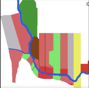
Logging Map Around Agustin’s Community
Greetings from the jungle,
The situation regarding logging in the forest is currently very fluid, with pressure from logging companies constantly increasing. A lot has happened in just the last few days, and we will share more detailed information with you shortly. Thanks to your support, we have managed to protect 27 hectares of the jungle over the past six months, for which we extend our heartfelt thanks. We have prepared a map of the area around the Agustin community, indicating territories according to the current logging status. It’s worth noting that the proportional size of areas on the map serves only as an approximate guide, as obtaining precise data from the cadastre in Ecuador is complicated. This information is usually accessible only to topographers and other specialists, but we are currently striving to obtain this data.
- Green: Života Postaru Territories
- Light green: Newly acquired within the last 6 months Života Postaru territories
- Yellow: Agustin’s family area
- Gray: Areas not threatened by logging
- Red: Areas affected by or still undergoing logging
- Light Red: Areas at risk of logging
- Brown: Rocky areas that are difficult to access for logging
- Blue: River